Site Location and Context
Background
The site extends to approximately 6.8 hectares and is located on the eastern edge of Eccleshall, south of Stone Road. It comprises primarily open agricultural land that gently slopes from west to east, with established hedgerows and boundary vegetation contributing to a well-defined edge. The site lies directly adjacent to the settlement boundary and adjoins a recently completed residential development to the west, creating a logical extension to the existing built form of the town.
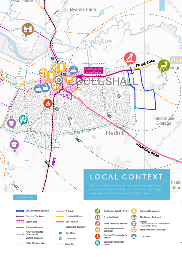
Eccleshall offers a wide range of local facilities, services, and community amenities. The site benefits from excellent accessibility to these, being located just 5–10 minutes’ walk from Eccleshall High Street via either Stone Road or an existing Public Right of Way (PRoW E17) that runs through the site, enhancing pedestrian and cycle connectivity. Bus stops are located within walking distance along Castle Street and Stone Road, served by the regular number 14 service which connects Eccleshall with Stafford and surrounding settlements.
The existing Public Right of Way will be retained and enhanced to provide a green spine through the development, connecting to the wider countryside and promoting sustainable travel. This will be complemented by the retention and enhancement of existing trees and hedgerows where possible, alongside new landscaping, green spaces, and public open space—particularly to the east—to support biodiversity, recreation, and a positive relationship with the surrounding landscape.
Overall, the site is well-located to accommodate new homes in a sustainable and integrated manner. It offers a natural extension to Eccleshall’s built form, is free from significant environmental constraints, and provides an opportunity to deliver a high-quality residential scheme that supports both existing and future community needs.
Hover over the image to zoom in.

|
 |
Planning Policy
The site is in Stafford Borough Council. The development plan is the Plan for Stafford Borough Part 1 (2014), Part 2 (2017) and the Eccleshall Neighbourhood Plan (2016). Settlement boundaries are set in the Local Plan and confirmed for Eccleshall in the Neighbourhood Plan.
The Local Plan planned about 10,000 homes, directing most growth to Stafford, then Stone, then the 11 Key Service Villages (including Eccleshall).
Because the plan is over five years old, the NPPF says the policies most important to deciding applications can be treated as out-of-date if the Council cannot show a five-year housing land supply. In those cases, the presumption in favour of sustainable development may apply.
The government has recently updated how housing need is calculated. Under this approach, Stafford Borough must plan for around 750 homes a year. To meet this, the Council must show enough deliverable land for five years. Currently there is only about 3.5 years’ supply—so there is a clear shortfall.
Eccleshall is a Key Service Village with strong services, facilities and access to jobs, so it is well placed to take a fair share of growth. Our proposals will help address the shortfall by delivering new homes in a sustainable, well-connected part of Eccleshall, with a mix of types and sizes, including affordable homes, to meet local needs and help people stay in the community.
Engagement
On 7 May 2025 we introduced our emerging proposals to Eccleshall Parish Council’s Planning Committee at the Community Centre, setting out an outline scheme on land south of Stone Road that would take access via that road, retain existing hedgerows and the public right of way, and incorporate two attenuation basins as part of the drainage strategy (see presentation screenshots below).


Key themes raised by councillors and residents included: the need for a housing mix with stronger provision for older residents/downsizers; concerns about loss of productive farmland; cumulative development pressure alongside other schemes and effects on local character; existing flood risk on Stone Road, in the town centre and around Castle Street; and the importance of coordinating with adjacent developers and securing community benefits. We confirmed that we would continue engagement via this website, inviting and responding to feedback submitted here.
